
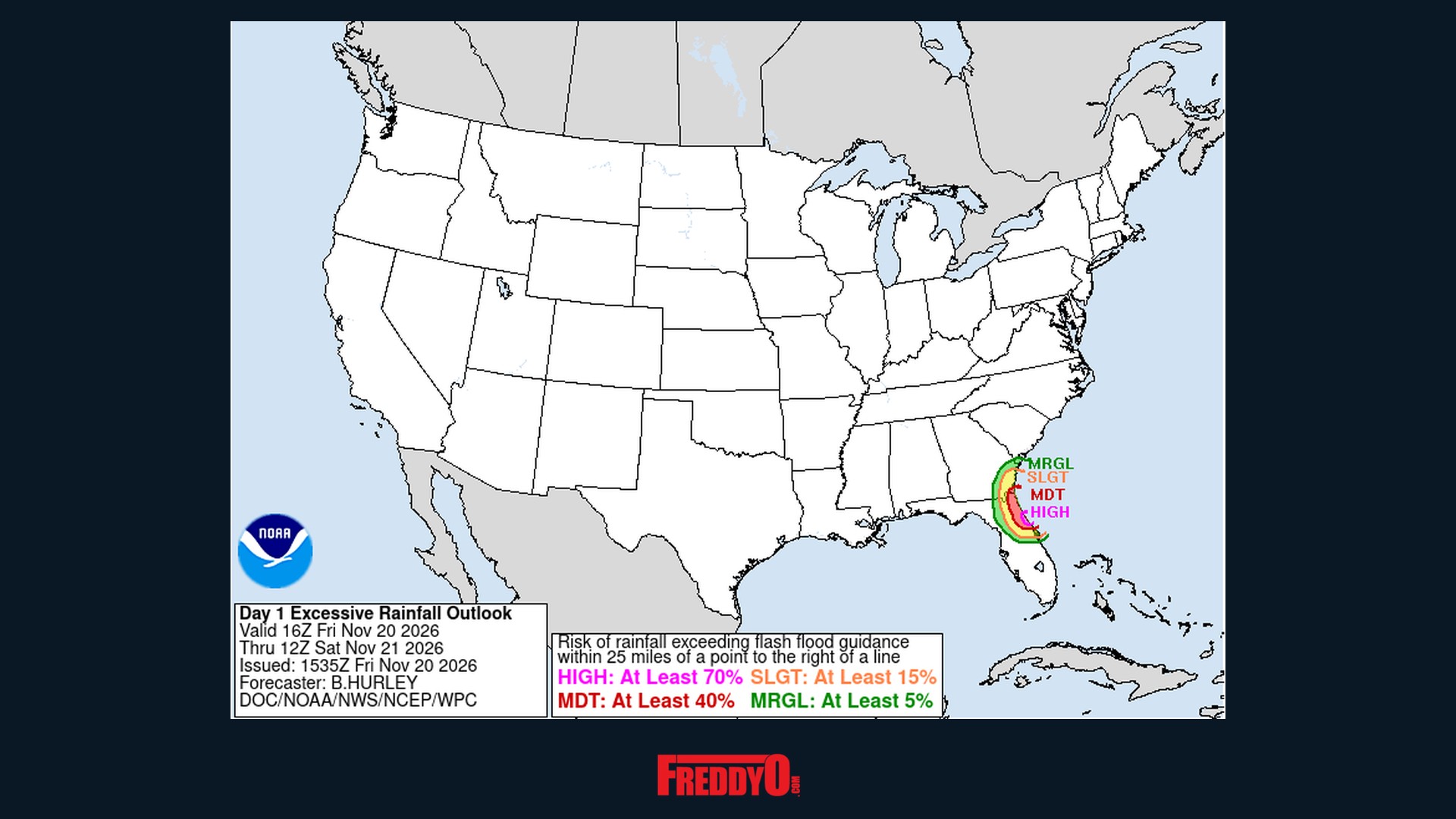
The official NOAA/NWS Weather Prediction Center excessive rainfall outlook for Friday, November 20, 2026 — the magenta zone on Florida’s east coast is a HIGH risk, the highest level there is. (NOAA/NWS, public domain)
FreddyO family, if your Thanksgiving plans run anywhere near the East Coast this weekend, stop and read this — because Florida is in the middle of a genuine flood emergency right now, and the same storm is about to ride up the coast straight into the busiest travel days of the year.
What Is Happening
A broad area of low pressure sitting just off Florida’s central east coast has been funneling days of torrential, tropical-moisture rain straight into the state. Parts of Florida’s Space Coast have already taken more than 15 inches of rain this week, flooding homes and forcing water rescues, CNN reports. More than 100 people were rescued from floodwaters in Brevard County on Thursday alone, and roughly 65 homes in the Palm Bay Estates mobile home park were placed under a mandatory evacuation after a bridge washed out and cut off the only access road.
The St. Johns River near Cocoa has risen above its previous record flood stage — it was measured at 18.70 feet Friday morning against a flood stage of 16 feet, and forecasters expect it to hold near that level into early next week, according to NOAA data reported by Florida Today. Schools across Brevard, Volusia, Broward, Palm Beach and Flagler counties closed Friday, Broward County, Fort Lauderdale and Hollywood have declared states of emergency, and Florida has activated the National Guard to help with rescues, FOX Weather reports.
Who Is at Risk — and When
The NOAA Weather Prediction Center has placed a small stretch of Florida’s east coast — Daytona Beach and the Flagler County coast — under a HIGH risk of excessive rainfall, Level 4 of 4, the highest level on the scale, in effect through Friday night into early Saturday. A broader Moderate risk (Level 3) covers more of the northeast Florida coast up through Jacksonville and into Camden County in southeast Georgia.
Do not let the word “risk” fool you — this is the real deal. High-risk flood days are rare: they are issued on fewer than 4% of days in a year, yet they account for more than 80% of all flood-related damage and 36% of flood-related deaths, according to Weather Prediction Center research cited by CNN. Forecasters warn of an additional 4 to 8 inches of rain near the coast through Saturday morning, falling at rates that could exceed 3 inches per hour on ground that is already completely saturated. Read the Weather Prediction Center’s full discussion here.
And the system may not be done making headlines. The National Hurricane Center’s Friday morning outlook says the low could acquire subtropical or tropical characteristics as it moves north along the coast this weekend — a 30% chance of formation within 48 hours and a 50% chance within 7 days. If it earns a name, it will be Kyle, the 11th named storm of the 2026 Atlantic season, USA Today reports. Name or no name, the impacts stay the same.

The National Hurricane Center’s seven-day outlook (Friday, November 20, 2026) — the shaded zone off the Southeast coast is where the storm could organize into Subtropical or Tropical Storm Kyle. (NHC/NOAA, public domain)
Thanksgiving Travel: The Weekend Goes Downhill From Here
AAA projects 81.5 million Americans will travel for Thanksgiving this year — and this storm’s timing could not be worse. Here is the day-by-day, per CNN’s latest forecast:
Saturday into Saturday night: Rain and gusty winds expand north into coastal Georgia and the Carolinas. Expect possible airport delays and flooded roads from Jacksonville, Florida, to Charleston, South Carolina, especially near the coast — and FOX Weather has northeastern Florida into coastal South Carolina under a Level 2 of 4 flash flood threat for Saturday. Beaches face erosion, high surf and coastal flooding.
Sunday into Sunday night: This is when the Mid-Atlantic and Northeast go downhill. Washington, DC’s airports could see rain from Sunday morning with no letup through the afternoon. Philadelphia and New York airports should be fine Sunday morning, but rain and gusty winds worsen conditions by the afternoon. Drivers get it too — slowdowns are likely along the heavily traveled Interstate 95 corridor from Virginia to New York City. Rain spreads across New England — Boston, Hartford and Providence — by late Sunday afternoon and evening.
Monday: Rain exits New England early Monday morning, but gusty winds could linger behind the storm. AccuWeather forecasts wind gusts of 40 to 60 mph along parts of the Southeast, Mid-Atlantic and New England coasts this weekend into Monday, plus a storm surge of 1 to 3 feet along much of the Atlantic coast, via USA Today.
Official Safety Guidance
The National Weather Service’s guidance is simple and it saves lives:
🚗 Turn Around, Don’t Drown. Never drive through flooded roads — most flood deaths happen in vehicles, and you cannot tell how deep the water is or whether the road underneath has washed away.
📱 Watch for flash flood warnings from your local National Weather Service office at weather.gov, especially overnight in the Florida high-risk zone.
✈️ Check your flight before you leave home. If you are flying anywhere along the East Coast Saturday through Monday, check your airline’s app for delays and rebooking options before heading to the airport.
🌊 Stay off the beaches. The Hurricane Center expects dangerous surf and rip currents along the Southeast and Mid-Atlantic coasts into early next week.
What Happens Next
The storm lifts north and exits New England on Monday — but Florida’s rivers will take days to fall, and the St. Johns is expected to stay near record levels into early next week. Forecasters are also watching yet another storm that could affect the Southeast and Northeast on Wednesday into Thanksgiving Day itself; it is too early for details, but if you are traveling late in the week, keep checking the forecast.
We will keep updating this story as the Weather Prediction Center and Hurricane Center issue new outlooks. Stay safe, check on your people in Brevard, Volusia and Flagler counties — and if you are anywhere in this storm’s path this weekend, drop your city in the comments and let the FreddyO family know how it looks where you are. 👇🏾















Leave a Reply